Mobile Doppler Lidar In Action
The fire lab recently tested our Halo Photonics Doppler Lidar in a new mobile configuration which allows us to record vertical velocity and aerosol backscatter while driving! The test deployments were conducted as part of a research project, CALGEM, in the southern portion of California's Central Valley. Our role in the project is to monitor the temporal and spatial evolution of the boundary-layer, which has important implications for the mixing of green house gases. While not exactly fire weather, the structure of the boundary layer plays a key role in fire behavior, and developing improved measurements will help us this summer when we deploy to big wildfires.
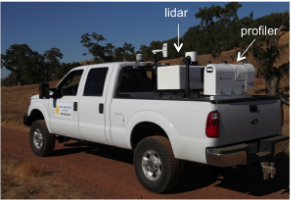
The Doppler lidar is mounted to the back of a Ford F-250 pickup truck (Fig. 1). In the past we've been able to deploy to a site, park the truck and then conduct scans and profiles of atmosphere. Now, with the addition of a solid state drive to the Lidar we can conduct vertical stare scans while the truck is in motion, opening up a range of new observational strategies! I'll show some examples below.
Figure 1. California State University Mobile Atmospheric Profiling System (CSU-MAPS). F250 with Halo Photonics Doppler Lidar and Microwave Profiler.
But first, prior to the mobile deployment, we operated the Lidar in the convectional fixed location setup to monitor the growth of the convective boundary layer (CBL) on 17 April. Figure 1 shows an overview of this data.
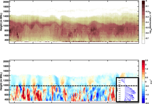
Figure 2. (a) Logarithmic backscatter intensity showing the variations in aerosol concentration and layering. (b) Vertical velocity (red=updrafts, blue=downdrafts). The black line with triangle markers shows the approximate height of the convective boundary layer (CBL) while the dashed line indicates the top of the aerosol layer.
The data reveal that the convective boundary layer (CBL) depth increases throughout the day, starting at ~800 m MSL and reaching ~1500 m MSL by mid-afternoon. The CBL top is apparent as the height to which surface based thermals (bright reds and blues in the bottom panel) penetrate. An unexpected and interesting feature on this day are gravity waves in the layer above the CBL. These waves are particularly apparent around 18:30 UTC (11:30 AM local), residing in the layer between the top of the CBL and the top of the aerosol layer (Fig. 2). It is likely that the waves result from the surface based thermals rising into the stable air aloft. As the rising plumes of heated air push up on the stable layer a wave motion is initiated.
Figure 3. Panels as in Fig. 2, but showing a detail of convective plumes and gravity waves. Note the up-down couplets of vertical velocity at a lower frequency and intensity in the layer above the CBL. These wave correspond to the undulations in the aerosol backscatter in the top panel.
An added factor in the generation of the gravity waves is the presence of a shear layer at 1000-m MSL (Fig. 3 inset). Below this level (e.g., within the CBL) the wind is from the Northwest and stability is about neutral, whereas aloft it is from the Southeast and the atmosphere is stratified. The transition zone has near zero velocity and ~180 degrees of direction shear, a condition that is sometimes associated with wave trapping, reflection, or ducting.
Now for the good stuff: After completing our primary objective of monitoring the CBL growth we conducted our first mobile deployment by driving an "up and over" transect of the Elk Hills, a small patch of complex terrain on the SW side of the valley. Figure 5 shows the driving route and truck speed, while Figure 6 shows the data that we collected.
Figure 5. Top panel shows the driving route across the Elk Hills near Bakersfield, CA. The bottom panel shows the truck speed (m/s). The speed drops to zero at stop signs.
Figure 6. Vertical velocity as a function of time and distance across the Elk Hills. Note that the CBL is now much deeper than earlier in the day, with the deepest plumes reaching to ~1800 m MSL. The ground elevation is shown in in grey, note that the first lidar data are about 100 m AGL.
The transect reveals that the CBL had grown appreciably in the late afternoon, likely due to destabilization of the airmass by an approaching cut-off low. It is also noteworthy that the CBL appears to be somewhat terrain following, with convective plumes above the hill crest reaching as high as 1800 m MSL whereas the CBL depth over the adjacent plain is ~1600 m MSL. The hill itself is about 200 m tall. In this single transect there is also a tendency for the most vigorous thermals to occur over the hill itself, suggesting that the elevated heating generated by the hill contributes to convergence in that region. The resulting enhanced plumes may mix pollution to greater depths than over the flat agricultural lands. Additional transects would be required to confirm this hypothesis.
Following Thursday's success we conducted a second mobile deployment on the afternoon of Friday 18 April. This time we did a complete west to east transect of the central valley (Fig. 7). The deployment was much longer, taking nearly an hour to complete. The data reveal the combined spatial and temporal variations in the convective updrafts and downdrafts as well as the variation in aerosol loading. For example, substantially higher aerosol concentrations were observed on the eastern third of the valley (Fig. 8).
Figure 7. Driving route on 18 April.
Figure 8. West-East transect of central valley. (a) vertical velocity, (b) Aerosol backscatter
We're extremely excited about the success of these first experimental mobile deployments. This summer we'll be extending these tests into the Sierra Nevada to examine the structure of the boundary layer over complex terrain during high fire danger days.


